Would it surprise you to know that three women, Tori Murden in 1999, Julie Wafaei in 2006, and Katie Spotz in 2010, rowed solo across the Atlantic? In fact, the number of recorded times individuals or small teams have rowed across the Atlantic and even the Pacific Ocean is now in double digits. The first recorded account of a team of two people to row across the Atlantic was in 1896, completed without the help of modern electronics or tools.
The jingle “In 1492 Columbus sailed the ocean blue” is so ingrained in our thinking that it’s hard to imagine that Columbus wasn’t the leader of the first team ever to row or sail across the Atlantic. But, some compelling evidence indicates that many people traveled across the oceans and mapped the places they visited well before the time of Columbus.
In 1492, some of the known regions of Europe and Northern Africa were not well surveyed, and maps of these areas were often inaccurate. Yet, somehow from the 1300s through the 1500s, accurate maps of places all over the world began to surface, especially with Turkish navigators and map makers.
Peri Reis, a Turkish naval officer, drew one of the most amazing of these maps in 1513 AD. Only a portion of the map is left, but there is enough to show accurate latitudinal and longitudinal lines between South America and Northern Africa. Antarctica also seemed to be included on his map, although it was drawn too far to the north.
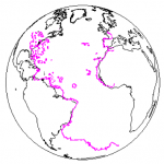
The following diagram shows the Peri Reis map overlayed on a modern map. The east coast of South American accurately matches the west coast of Africa along hundreds of miles.

One of the maps that was used by Reis was said to belong to “Colombo,” possibly Christopher Columbus, although the extent of Columbus’ exploration was limited to only a few places on the Reis map.
Most archeologists are sure that neither Columbus nor Reis personally explored, surveyed, and mapped five continents. The fact that Reis was not the original map maker can be verified by the information found on the map. First of all, there are 5 reference points, marked radially equidistant from the same location in Egypt, pointing to an ancient Prime Meridian there. There was also a note that his map had been pieced together from a variety of maps, some of which had been recovered from the Library at Alexandria.
Other similar maps have been discovered from this general time period. Oronteus Finneus also compiled a map in 1531 AD that shows mountain ranges, river valleys, and bays on Antarctica without the ice cover we find today.
Ibn Ben Zara compiled a map from ancient Tyranean maps. It shows coastlines and islands of the Mediterranean Sea. The shorelines of this map are much more accurate than the ones produced by medieval map makers of the 1500s. Chinese map makers also left their own accurately drawn maps of places in Asia.
A college professor by the name of Charles Hapgood has done much research on these and other ancient maps. He has stood his ground in opposition to some archeologists who downplay what the maps show. He analyzed the accuracy of these ancient maps and concluded that the map makers undoubtedly used very advanced surveying methods and instruments.
Hapgood worked with the U.S. Air Force cartographers for two years. They concluded that the Reis map could reasonably be identified with existing mountain ranges, rivers, and bays in Antarctica.
So, who drew the original maps?
We know the Phoenician sailors were among the earliest people to acquire accurate mapping and navigational skills. For many years the Phoenician city of Tyre was virtually an impregnable sea port. It was located in the eastern Mediterranean coast on an island. It was incredibly rich and influential as a result of their shipping trade. Their navigational skills gave them a powerful edge over other nations. Their maps seem to have been carefully guarded and treasured until 332 B.C. when Alexander the Great conquered the Phonician city of Tyre after a long seige.
The maps and other records of the Tyre sailors were kept in the library of Alexander until the entire library was eventually ransacked and burned over an extended period. However, the maps were recognized as valuable by some unknown person or group and saved.
After a lapse of hundreds of years, map makers from Turkey and a few other places apparently discovered some these ancient maps and began incorporating them into the maps they already had.
There are a wide range of opinions about these maps. People who agree with the official story of the earth’s history (that man evolved from ape-like animals and gradually learned to use tools over millions of years) generally debunk the maps.
I take a position that agrees with the Genesis account of early man. I believe that the very early civilizations were descendants of the survivors of the worldwide Flood. They came out of a world that possessed great knowledge and advanced technologies. They were physically fit and extremely intelligent. Some of these early humans rapidly recovered and developed mathematics, science, and technologies that allowed them to calculate the size of the earth, draw accurate maps, and construct ships and buildings that required advanced engineering skills.
The next few articles will discuss other findings of 3000 to 4000 year old civilizations.
Thanks for the information about Navigation Through the Ages. I plan to check on this. It sounds extremely interesting.